Պատկեր:European microstates map.svg

Size of this PNG preview of this SVG file: 553 × 600 պիքսել. Այլ թույլտվությաններ: 221 × 240 պիքսել | 442 × 480 պիքսել | 708 × 768 պիքսել | 944 × 1024 պիքսել | 1888 × 2048 պիքսել.
Սկզբնական նիշք (SVG-նիշք, անվանապես 553 × 600 փիքսել, նիշքի չափը՝ 1,18 ՄԲ)
Ամփոփում
| Նկարագրում |
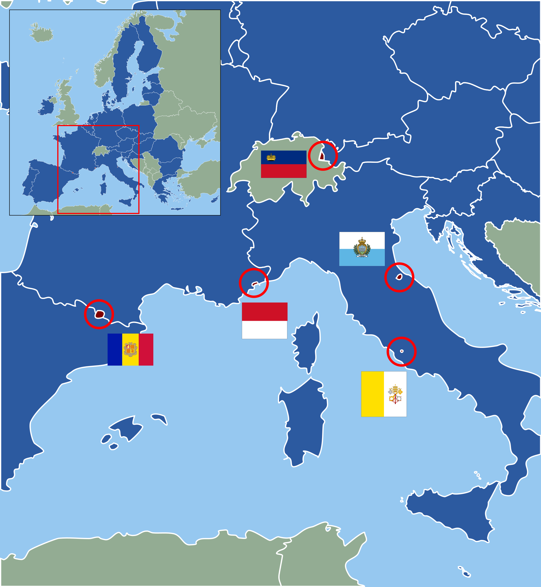
Deutsch: Karte der europäischen Zwergstaaten und der Europäischen Union (2013). Staaten der EU sind blau, Zuordnung der Mikrostaaten nach ihren Flaggen wie folgt:
English: Map of European Microstates and the European Union in 2013. The European Union is in blue, microstate flags as follows:
|
| Թվական | (UTC) |
| Աղբյուր | |
| Հեղինակ |
|
| Սա խմբագրված պատկեր է, որը համեմատ բնօրինակին ենթարկվել է թվային մշակման։ Փոփոխությունները՝ Vectorization under usage of blank svg map: Սկզբնական պատկերը գտնվում է այստեղ՝ European Microstates Map.png։ Խմբագրել է Master Uegly մասնակիցը։
|
Արտոնագրում
Այս նիշքը հասանելի է Creative Commons Attribution-Share Alike 3.0 Unported արտոնագրի ներքո:
- Դուք ազատ եք՝
- կիսվել ստեղծագործությամբ – պատճենել, տարածել և փոխանցել այս աշխատանքը։
- վերափոխել – ադապտացնել աշխատանքը
- Պահպանելով հետևյալ պայմանները'
- հղում – Դուք պետք է նշեք հեղինակի (իրավատիրոջ) հղումը:
- համանման տարածում – Եթե դուք ձևափոխում եք, փոխակերպում, կամ այս աշխատանքի հիման վրա ստեղծում եք նոր աշխատանք, ապա ձեր ստեղծածը կարող է տարածվել միայն նույն կամ համարժեք թույլատրագրով։
Original upload log
This image is a derivative work of the following images:
- File:Blank_map_of_Europe.svg licensed with Cc-by-sa-2.5
- 2011-09-19T22:57:58Z Alphathon 680x520 (603759 Bytes) Added North/Northern Cyprus
- 2011-08-23T10:26:48Z Heb 680x520 (604212 Bytes) Added [[:en:Bornholm]] (taken from [[:File:Denmark blank map.svg]])
- 2011-04-12T00:40:40Z Alphathon 680x520 (602549 Bytes) Upgraded Sicily based on "File:Freeworldmaps-sicily.jpg". Upgraded Malta based on "File:Map of Malta 2.png". Simplified Croatian borders.
- 2011-04-10T21:43:04Z Alphathon 680x520 (607359 Bytes) Upgraded Croatia, Bosnia & Herzegovina, Slovenia and surrounding countries based on data from "File:Kroatien - Politische Gliederung (Karte).png"
- 2011-04-10T20:05:09Z Alphathon 680x520 (568373 Bytes) Improved Serbia, Montenegro and surrounding countries using data from "File:Serbia Map.png". Fixed Serbia-Montenegro border. Added Kosovo (using dashed border, since it is not a universally recognised nation, and left the lan
- 2011-04-10T15:55:02Z Alphathon 680x520 (524980 Bytes) Tweaked Ukraine and surrounding countries based on data from "File:Up-map.png"
- 2011-04-10T04:02:09Z Alphathon 680x520 (511168 Bytes) Improved Greece, Albania, F.Y.R. Macedonia and Bulgaria based on "File:Greece topo.jpg"
- 2011-04-10T02:48:52Z Alphathon 680x520 (505569 Bytes) Tweaked Germany and surrounding countries based on info from "File:Germany_general_map.png"
- 2011-04-10T01:54:05Z Alphathon 680x520 (493733 Bytes) Converted all lakes back to separate layer. Added Finish lakes and tweaked Finland shape based on "File:Finland 1996 CIA map.jpg". Added Swiss lakes based on "File:Suisse cantons.svg". Tweaked Scotland and added Lochs.
- 2011-04-10T00:07:54Z Alphathon 680x520 (450120 Bytes) Improved England outline and added Isle of Wight based on "File:England Regions - Blank.svg". Improved Denmark based on "File:2 digit postcode danmark.png". Improved Sweden based on "File:Map of Sweden, CIA, 1996.jpg"
- 2011-04-08T15:53:07Z Alphathon 680x520 (438878 Bytes) Upgraded/fixed various parts of the map. Details: *Some minor fixes to Ireland and added some of the larger lakes based on [[:File:Ireland_trad_counties_named.svg]] *Pretty major fixes to Scotland (mainly the west coast and i
- (10 more entrys follow)
- File:European_Microstates_Map.png licensed with PD-self
- 2007-06-20T12:16:46Z JLogan 212x217 (8731 Bytes) {{Information |Description=Map of European Microstates |Source=self-made |Date=12 March 2007 |Author= [[User:JLogan|JLogan]] }}
Uploaded with derivativeFX
Նիշքի պատմություն
Մատնահարեք օրվան/ժամին՝ նիշքի այդ պահին տեսքը դիտելու համար։
| Օր/Ժամ | Մանրապատկեր | Օբյեկտի չափը | Մասնակից | Մեկնաբանություն | |
|---|---|---|---|---|---|
| ընթացիկ | 13:04, 27 փետրվարի 2022 | | 553 × 600 (1,18 ՄԲ) | Welkend | own mistake corrected (Iceland) |
| 12:58, 27 փետրվարի 2022 |  | 553 × 600 (1,17 ՄԲ) | Welkend | own mistake corrected (red circle around Monaco) | |
| 12:56, 27 փետրվարի 2022 |  | 553 × 600 (1,17 ՄԲ) | Welkend | little cosmetic corrections of the borders of the map and the shape of Monaco | |
| 11:41, 2 փետրվարի 2020 |  | 553 × 600 (1,17 ՄԲ) | NordNordWest | upd | |
| 11:40, 30 Հունիսի 2013 |  | 553 × 600 (1,17 ՄԲ) | NordNordWest | upd | |
| 23:59, 9 Դեկտեմբերի 2011 |  | 553 × 600 (1,17 ՄԲ) | Master Uegly | == {{int:filedesc}} == {{Information |Description={{de|Karte der europäischen Zwergstaaten und der Europäischen Union (2010). Staaten der EU sind blau, Zuordnung der Mikrostaaten nach ihren Flaggen wie folgt:}} {{en|Map of European Microstates and the E |
Նիշքի օգտագործում
Հետևյալ էջը հղվում է այս նիշքին՝
Նիշքի համընդհանուր օգտագործում
Հետևյալ այլ վիքիները օգտագործում են այս նիշքը՝
- Օգտագործումը az.wikipedia.org կայքում
- Օգտագործումը cs.wikipedia.org կայքում
- Օգտագործումը de.wikipedia.org կայքում
- Օգտագործումը es.wikipedia.org կայքում
- Օգտագործումը fa.wikipedia.org կայքում
- Օգտագործումը fi.wikipedia.org կայքում
- Օգտագործումը fr.wikipedia.org կայքում
- Օգտագործումը hr.wikipedia.org կայքում
- Օգտագործումը lb.wikipedia.org կայքում
- Օգտագործումը pl.wikipedia.org կայքում
- Օգտագործումը pt.wikipedia.org կայքում
- Օգտագործումը ru.wikipedia.org կայքում
- Օգտագործումը sv.wikipedia.org կայքում
- Օգտագործումը th.wikipedia.org կայքում
- Օգտագործումը uk.wikipedia.org կայքում
- Օգտագործումը www.wikidata.org կայքում
- Օգտագործումը zh.wikipedia.org կայքում