Պատկեր:Europe and the Near East at 476 AD.png

Նախադիտման չափ՝ 800 × 556 պիքսել։ Այլ թույլտվությաններ: 320 × 222 պիքսել | 640 × 445 պիքսել | 1024 × 712 պիքսել | 1280 × 890 պիքսել | 2830 × 1967 պիքսել.
Սկզբնական նիշք (2830 × 1967 փիքսել, նիշքի չափը՝ 1,58 ՄԲ, MIME-տեսակը՝ image/png)

|
This historical map image could be re-created using vector graphics as an SVG file. This has several advantages; see Commons:Media for cleanup for more information. If an SVG form of this image is available, please upload it and afterwards replace this template with
{{vector version available|new image name}}.
It is recommended to name the SVG file “Europe and the Near East at 476 AD.svg”—then the template Vector version available (or Vva) does not need the new image name parameter. |
Ամփոփում
| Նկարագրում |
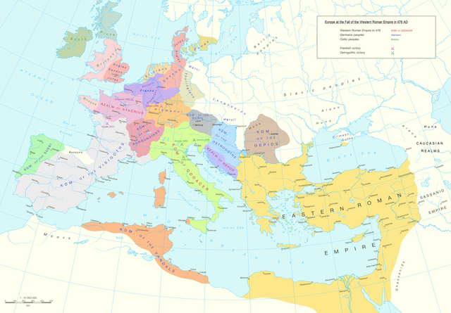
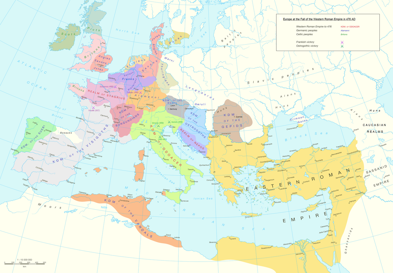
English: Political division in Europe, North Africa and Near East after the end of the Western Roman Empire in 476 AD. Romance area added since H. M. Glessegen (dir.), Handbuch der Romanische Sprachgeschichte, Berlin/New York, p. 544-555. Modified Gaëls / Picts / Britons (see discussion file).
Español: Mapa político de Europa, el Norte de África y Oriente Próximo tras el fin del Imperio Romano de Occidente en 476 d.C. Área románica añadida desde H. M. Glessegen (dir.), Handbuch der Romanische Sprachgeschichte, Berlín/Nueva York, p. 544-555. Gaëls / Pictos / Británicos modificados (ver archivo de discusión).
Français : L'Europe, l'Afrique du Nord et le Proche-Orient après la fin de l'Empire romain d'Occident en 476. Limites des langues romanes ajoutées d'après H. M. Glessegen (dir.), Handbuch der Romanische Sprachgeschichte, Berlin/New York, p. 544-555. Modifié les Gaëls / Pictes / Bretons d'après la page de discussion. |
| Թվական | |
| Աղբյուր | Putzger Historischer Weltatlas, Cornelsen, Berlin 1992 ISBN 3-464-00176-8, pp. 34-35 (maps by R. Hachmann). |
| Հեղինակ | Guriezous |
| Իրավունքներ (Նիշքի վերաօգտագործումը) |
Բեռնողի սեփական աշխատանք |
Արտոնագրում
Ես, սույն աշխատանքի հեղինակային իրավունքների տերը, այսուհետ այն հրատարակում եմ հետևյալ արտոնագրի ներքո։
This file is licensed under the Creative Commons Attribution-Share Alike 4.0 International license.
- Դուք ազատ եք՝
- կիսվել ստեղծագործությամբ – պատճենել, տարածել և փոխանցել այս աշխատանքը։
- վերափոխել – ադապտացնել աշխատանքը
- Պահպանելով հետևյալ պայմանները'
- հղում – Դուք պետք է նշեք հեղինակի (իրավատիրոջ) հղումը:
- համանման տարածում – Եթե դուք ձևափոխում եք, փոխակերպում, կամ այս աշխատանքի հիման վրա ստեղծում եք նոր աշխատանք, ապա ձեր ստեղծածը կարող է տարածվել միայն նույն կամ համարժեք թույլատրագրով։
Նիշքի պատմություն
Մատնահարեք օրվան/ժամին՝ նիշքի այդ պահին տեսքը դիտելու համար։
| Օր/Ժամ | Մանրապատկեր | Օբյեկտի չափը | Մասնակից | Մեկնաբանություն | |
|---|---|---|---|---|---|
| ընթացիկ | 12:14, 5 Հոկտեմբերի 2023 | | 2830 × 1967 (1,58 ՄԲ) | GPinkerton | Reverted to version as of 03:35, 9 January 2022 (UTC) this manipulation of maps is forbidden COM:CROP |
| 09:47, 24 Սեպտեմբերի 2023 |  | 2830 × 1967 (1,79 ՄԲ) | Claude Zygiel | Add details romance languages of the time according with the article "Romance languages" | |
| 16:52, 22 Սեպտեմբերի 2023 |  | 2830 × 1967 (1,78 ՄԲ) | Claude Zygiel | Gaëls. All germanic peoples colored. Romance area added since H. M. Glessegen (dir.), {{de}} ''Handbuch der Romanische Sprachgeschichte'', Berlin/New York, p. 544-555. | |
| 03:35, 9 հունվարի 2022 |  | 2830 × 1967 (1,58 ՄԲ) | Jul059 | Lossless file size reduction | |
| 15:33, 7 Մայիսի 2016 |  | 2830 × 1967 (2,2 ՄԲ) | Guriezous | Eliminados nombres | |
| 20:08, 5 Մայիսի 2016 |  | 2830 × 1967 (2,21 ՄԲ) | Guriezous | Añadidos nombres. | |
| 17:43, 4 Մայիսի 2016 |  | 2830 × 1967 (2,2 ՄԲ) | Guriezous | Eliminados nombres rezagados. | |
| 08:52, 24 Ապրիլի 2016 |  | 2830 × 1967 (2,21 ՄԲ) | Guriezous | Eliminados nombres de provincias en gran parte aleatorias | |
| 10:12, 16 Ապրիլի 2016 |  | 2830 × 1967 (2,29 ՄԲ) | Guriezous | Eliminada Austrasia | |
| 10:11, 16 Ապրիլի 2016 |  | 2830 × 1967 (2,29 ՄԲ) | Guriezous | Eliminada Austrasia |
Նիշքի օգտագործում
Հետևյալ 3 էջերը հղվում են այս նիշքին՝
Նիշքի համընդհանուր օգտագործում
Հետևյալ այլ վիքիները օգտագործում են այս նիշքը՝
- Օգտագործումը ar.wikipedia.org կայքում
- Օգտագործումը ast.wikipedia.org կայքում
- Օգտագործումը azb.wikipedia.org կայքում
- Օգտագործումը bg.wikipedia.org կայքում
- Օգտագործումը bn.wikipedia.org կայքում
- Օգտագործումը ca.wikipedia.org կայքում
- Օգտագործումը cs.wikipedia.org կայքում
- Օգտագործումը de.wikipedia.org կայքում
- Օգտագործումը de.wikibooks.org կայքում
- Օգտագործումը de.wikiversity.org կայքում
- Օգտագործումը el.wikipedia.org կայքում
- Օգտագործումը en.wikipedia.org կայքում
- Alemanni
- Frisians
- Germanic peoples
- Middle Ages
- Marcomanni
- Ostrogoths
- Saxons
- Visigoths
- Vandals
- Rugii
- Thuringii
- Zeno (emperor)
- Migration Period
- Basiliscus
- Gepids
- Timeline of Jerusalem
- Campaign history of the Roman military
- Succession of the Roman Empire
- Fall of the Western Roman Empire
- French people
- Germanic kingship
Տեսնել այս նիշքի ավելի համընդհանուր օգտագործումը: