Սկզբնական նիշք(SVG-նիշք, անվանապես 512 × 512 փիքսել, նիշքի չափը՝ 42 ԿԲ)

Render this image in .

Այս նիշքը տեղադրված է Վիքիպահեստում է և այն կարող է օգտագործվել այլ նախագծերի կողմից։ Վիքիպահեստում նիշքի մասին տեղեկությունների հիմնական մասը ներկայացված է ստորև։

Սա անիմացված SVG-նիշք է: Վերևի նախադիտումը կարող է լինել սխալ կամ կիսատ: Ինտերակտիվ հնարավորությունների օգտագործման համար բացեք File:Comparison satellite navigation orbits.svg դիտարկչում, որը կարող է SVG-նիշքերի հետ աշխատել, օրինակ՝ Opera կամ Internet Explorer Adobe SVG պլագինի հետ:

Templates:Animated SVG/I18n
العربية | Boarisch | বাংলা | català | čeština | Deutsch | Deutsch (Sie-Form)‎ | English | español | فارسی | suomi | français | galego | עברית | हिन्दी | magyar | հայերեն | íslenska | italiano | 日本語 | 한국어 | lietuvių | македонски | മലയാളം | Plattdüütsch | Nederlands | occitan | português | português do Brasil | русский | sicilianu | slovenščina | svenska | ไทย | українська | 中文 | 中文(简体)‎ | 中文(繁體)‎ | +/−

Ամփոփում

Նկարագրում
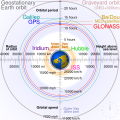
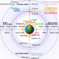
English: Comparison of GPS, GLONASS, Galileo and COMPASS (medium Earth orbit satellites) orbits with International Space Station, Hubble Space Telescope, geostationary and graveyard orbits, and the nominal size of the Earth.


For this diagram, the 3-dimensional aspect of orbits have been flattened. For instance, the view of the Earth depicted is looking down to the North Pole which makes the orbit representations appear to be equatorial. While this is accurate for geostationary orbits, other orbits listed are actually at significant inclinations. The inclination of Iridium orbits is at 86.4° which is nearly perpendicular to the diagrammed plane. Looking down to the North Pole from this zenith, a polar orbit of 90° inclination would actually appear as a straight line.
Français : Comparaison des orbites GPS, GLONASS, Galileo, Iridium et Beidou avec celles de la Station spatiale internationale et Hubble ainsi que l'orbite géostationnaire, l'orbite de rebut et la taille de la Terre.


Pour ce diagramme, l'aspect tridimensionnel des orbites a été ignoré : tout est aplati. La Terre est représentée avec le pôle Nord au centre, ce qui fait que les orbites semblent équatoriales. Ceci est correct dans le cas des orbites géostationnaires, mais les autres sont en réalité inclinées. Les satellites Iridium sont le cas le plus extrême, avec 86,4° d'inclinaison, les plaçant presque à la perpendiculaire du plan représenté. Si leur orbite était représentée de façon fidèle, nous ne verrions qu'une ligne droite sur ce diagramme.
Աղբյուր Բեռնողի սեփական աշխատանք
Հեղինակ cmglee
Այլ մեկնակերպներ

[խմբագրել]

English: Animated
Español: Animada
Македонски: Анимирано
Русский: Мультипликация
Українська: Анімація
English: Static
Македонски: Обична слика
Русский: Обычная картинка
Українська: Статичне зображення
SVG genesis
InfoField
 
Սա վեկտոր գրաֆիկական պատկեր է ստեղծված է եղել Other tools օգնությամբ: .
 
 This diagram is translated using SVG switch elements: all translations are stored in the same file.

Assessment

Media of the day This file was selected as the media of the day for 12 August 2020. It was captioned as follows:
English: A detailed and informative diagram that brings to life where different satellites (e.g. the International Space Station vs. the GPS satellites) are physically located relative to Earth
Other languages
Čeština: Detailní diagram ukazující, kde se na oběžné dráze kolem Země fyzicky nacházejí různé uměle vyrobené satelity, např. Mezinárodní vesmírná stanice nebo součásti sysému GPS.
English: A detailed and informative diagram that brings to life where different satellites (e.g. the International Space Station vs. the GPS satellites) are physically located relative to Earth
Français : Diagramme animé présentant les principales orbites des satellites artificiels autour de la Terre.

Featured media
This is a featured media on Wikimedia Commons and is considered one of the finest files.

If you have a file of similar quality that can be published under a suitable copyright license, be sure to upload it, tag it, and nominate it.

Վիքիպեդիա

 This is a featured picture on the անգլերեն language Wikipedia (Featured pictures) and is considered one of the finest images.

If you think this file should be featured on Wikimedia Commons as well, feel free to nominate it.
If you have an image of similar quality that can be published under a suitable copyright license, be sure to upload it, tag it, and nominate it.

Արտոնագրում

Ես, այս աշխատանքի հեղինակային իրավունքների տերը, ներկա հրատարակում եմ սրա հետևյալ լիցենզիաների պայմաններով
w:en:Creative Commons
հղում համանման տարածում
Այս նիշքը հասանելի է Creative Commons Attribution-Share Alike 3.0 Unported արտոնագրի ներքո:
Դուք ազատ եք՝
  • կիսվել ստեղծագործությամբ – պատճենել, տարածել և փոխանցել այս աշխատանքը։
  • վերափոխել – ադապտացնել աշխատանքը
Պահպանելով հետևյալ պայմանները'
  • հղում – Դուք պետք է նշեք հեղինակի (իրավատիրոջ) հղումը:
  • համանման տարածում – Եթե դուք ձևափոխում եք, փոխակերպում, կամ այս աշխատանքի հիման վրա ստեղծում եք նոր աշխատանք, ապա ձեր ստեղծածը կարող է տարածվել միայն նույն կամ համարժեք թույլատրագրով։
GNU head Այս վավերագրման պատճենահանման, տարածման և/կամ ձևափոխման թույլտվություն կամ լիցենզիայի GNU FDL պայմաններով 1.2 մեկնակերպի կամ ավելի ուշ, հրատարակված Ազատ ծրագրային ապահովության հիմնադրամում, առանց անփոփոխելի հատվածների, առանց բնագիրների, որոնք տեղադրված են առաջին և վերջին շապիկներում: Լիցենզիայի պատճենը գտնվում է GNU Free Documentation License հատվածում:
Կարող եք ընտրել այս թույլատրագրերից ցանկացածը։
Annotations
InfoField
This image is annotated: View the annotations at Commons

Captions

Add a one-line explanation of what this file represents
Earth satellite orbits

checksum անգլերեն

2cf5d382b563a0eac7ecd7322d221f0fb0d6bbbb

data size անգլերեն

43 502 Բայթ

512 փիքսել

512 փիքսել

Նիշքի պատմություն

Մատնահարեք օրվան/ժամին՝ նիշքի այդ պահին տեսքը դիտելու համար։

(ամենաթարմ | ամենահին) Դիտել (ավելի թարմ 10 | ) (10 | 20 | 50 | 100 | 250 | 500)
Օր/ԺամՄանրապատկերՕբյեկտի չափըՄասնակիցՄեկնաբանություն
ընթացիկ04:48, 27 փետրվարի 202104:48, 27 փետրվարի 2021 տարբերակի մանրապատկերը512 × 512 (42 ԿԲ)GlrxFix SVG errors: systemLanguage attr on desc element; misuse of switch element; use SVG 2.0 rules; delete DOCTYPE
14:49, 24 Սեպտեմբերի 202014:49, 24 Սեպտեմբերի 2020 տարբերակի մանրապատկերը512 × 512 (43 ԿԲ)DrhymeFile uploaded using svgtranslate tool (https://svgtranslate.toolforge.org/). Added translation for ko.
14:44, 24 Սեպտեմբերի 202014:44, 24 Սեպտեմբերի 2020 տարբերակի մանրապատկերը512 × 512 (40 ԿԲ)DrhymeFile uploaded using svgtranslate tool (https://svgtranslate.toolforge.org/). Added translation for ko.
14:35, 24 Սեպտեմբերի 202014:35, 24 Սեպտեմբերի 2020 տարբերակի մանրապատկերը512 × 512 (36 ԿԲ)DrhymeFile uploaded using svgtranslate tool (https://svgtranslate.toolforge.org/). Added translation for ko.
19:41, 22 Սեպտեմբերի 202019:41, 22 Սեպտեմբերի 2020 տարբերակի մանրապատկերը512 × 512 (29 ԿԲ)CmgleeReverted to version as of 18:10, 19 August 2020 (UTC) as text is now misaligned and descriptions are removed
11:31, 21 Սեպտեմբերի 202011:31, 21 Սեպտեմբերի 2020 տարբերակի մանրապատկերը512 × 512 (23 ԿԲ)Leonel SohnsValid SVG.
18:10, 19 Օգոստոսի 202018:10, 19 Օգոստոսի 2020 տարբերակի մանրապատկերը512 × 512 (29 ԿԲ)RavenpuffSpecify supplementary systemLanguage="en" in switch tags as per Commons guidance
01:11, 19 Օգոստոսի 202001:11, 19 Օգոստոսի 2020 տարբերակի մանրապատկերը512 × 512 (25 ԿԲ)CmgleeFix broken hover effects and redundant text.
17:55, 30 Հունիսի 202017:55, 30 Հունիսի 2020 տարբերակի մանրապատկերը512 × 512 (33 ԿԲ)Galaktoschange http: to https: (except in doctype or xmlns) and wikipedia.org to en.wikipedia.org
19:43, 23 Հունիսի 202019:43, 23 Հունիսի 2020 տարբերակի մանրապատկերը512 × 512 (33 ԿԲ)CmgleeTry again
(ամենաթարմ | ամենահին) Դիտել (ավելի թարմ 10 | ) (10 | 20 | 50 | 100 | 250 | 500)

Հետևյալ էջը հղվում է այս նիշքին՝

Նիշքի համընդհանուր օգտագործում

Հետևյալ այլ վիքիները օգտագործում են այս նիշքը՝

Տեսնել այս նիշքի ավելի համընդհանուր օգտագործումը:

Մետատվյալներ