Պատկեր:Buskerud Municipalities.png
Նախադիտման չափ՝ 800 × 487 պիքսել։ Այլ թույլտվությաններ: 320 × 195 պիքսել | 640 × 390 պիքսել | 1025 × 624 պիքսել.
Սկզբնական նիշք (1025 × 624 փիքսել, նիշքի չափը՝ 19 ԿԲ, MIME-տեսակը՝ image/png)
Transferred from en.wikipedia to Commons by Maksim.
The original description page was here. All following user names refer to en.wikipedia.
Ամփոփում
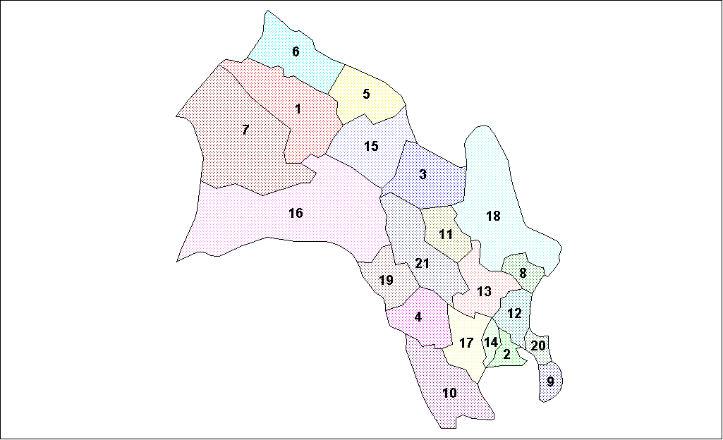
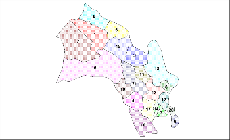
Map of the municipalities of Buskerud County in Norway. Created by Rarelibra for public domain use. Created using MapInfo Professional v7.5 and various mapping resources.
Արտոնագրում
| I, the copyright holder of this work, release this work into the public domain. This applies worldwide. In some countries this may not be legally possible; if so: I grant anyone the right to use this work for any purpose, without any conditions, unless such conditions are required by law. |
| date/time | username | edit summary |
|---|---|---|
| 19:48, 26 January 2006 | en:User:Rarelibra | (Map of the municipalities of Buskerud County in Norway. Created by <a href="/wiki/User:Rarelibra" title="User:Rarelibra">Rarelibra</a> for public domain use. Created using MapInfo Professional v7.5 and various mapping resources.) |
Original upload log
Legend: (cur) = this is the current file, (del) = delete this old version, (rev) = revert to this old version.
Click on date to download the file or see the image uploaded on that date.
- (del) (cur) 19:48, 26 January 2006 . . en:User:Rarelibra Rarelibra ( en:User_talk:Rarelibra Talk) . . 1025x624 (19651 bytes) (Map of the municipalities of Buskerud County in Norway. Created by en:User:Rarelibra Rarelibra for public domain use. Created using MapInfo Professional v7.5 and various mapping resources.)
Նիշքի պատմություն
Մատնահարեք օրվան/ժամին՝ նիշքի այդ պահին տեսքը դիտելու համար։
| Օր/Ժամ | Մանրապատկեր | Օբյեկտի չափը | Մասնակից | Մեկնաբանություն | |
|---|---|---|---|---|---|
| ընթացիկ | 21:10, 3 Օգոստոսի 2007 | | 1025 × 624 (19 ԿԲ) | Rarelibra | Map of the municipalities of Buskerud County in Norway. Created by Rarelibra for public domain use. Created using MapInfo Professional v7.5 and various mapping resources. |
| 12:23, 26 Մարտի 2006 |  | 1025 × 624 (19 ԿԲ) | Maksim | La bildo estas kopiita de wikipedia:en. La originala priskribo estas: == Summary == Map of the municipalities of Buskerud County in Norway. Created by Rarelibra for public domain use. Created using MapInfo Professional v7.5 and various |
Նիշքի օգտագործում
Հետևյալ էջը հղվում է այս նիշքին՝
Նիշքի համընդհանուր օգտագործում
Հետևյալ այլ վիքիները օգտագործում են այս նիշքը՝
- Օգտագործումը ast.wikipedia.org կայքում
- Օգտագործումը bat-smg.wikipedia.org կայքում
- Օգտագործումը da.wikipedia.org կայքում
- Օգտագործումը en.wikipedia.org կայքում
- Օգտագործումը eo.wikipedia.org կայքում
- Օգտագործումը es.wikipedia.org կայքում
- Օգտագործումը et.wikipedia.org կայքում
- Օգտագործումը eu.wikipedia.org կայքում
- Օգտագործումը hu.wikipedia.org կայքում
- Օգտագործումը id.wikipedia.org կայքում
- Օգտագործումը nl.wikipedia.org կայքում
- Օգտագործումը pl.wikipedia.org կայքում
- Օգտագործումը pt.wikipedia.org կայքում
- Օգտագործումը ru.wikipedia.org կայքում
- Օգտագործումը sh.wikipedia.org կայքում
- Օգտագործումը tr.wikipedia.org կայքում
- Օգտագործումը uk.wikipedia.org կայքում
- Օգտագործումը vi.wikipedia.org կայքում