Պատկեր:Battle of Borodino 1812 map.jpg
Նախադիտման չափ՝ 800 × 575 պիքսել։ Այլ թույլտվությաններ: 320 × 230 պիքսել | 640 × 460 պիքսել | 1024 × 736 պիքսել | 1280 × 921 պիքսել | 1524 × 1096 պիքսել.
Սկզբնական նիշք (1524 × 1096 փիքսել, նիշքի չափը՝ 594 ԿԲ, MIME-տեսակը՝ image/jpeg)
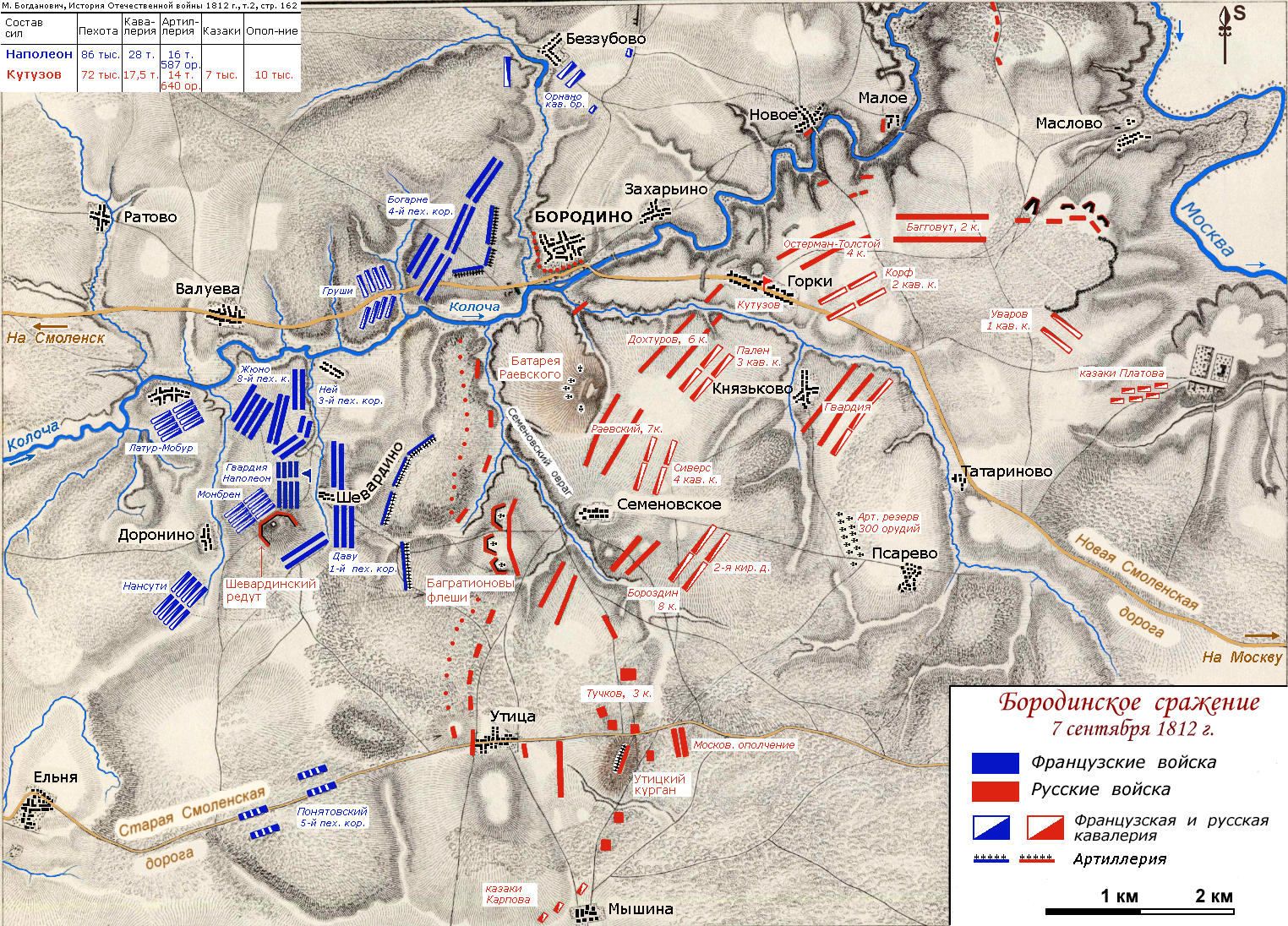
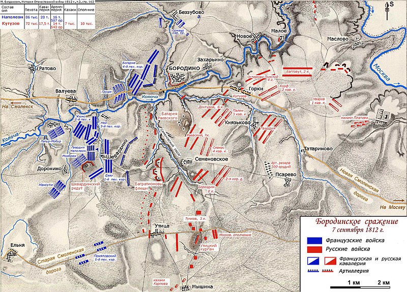
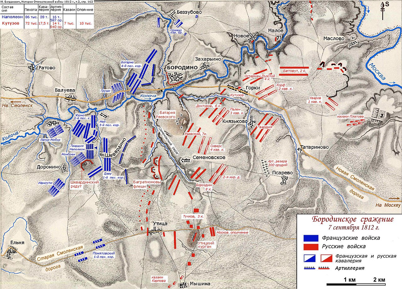
| Նկարագրում | Map of the troops positions in the morning of September, 7, 1812. Battle of Borodino or Bataille de la Moskowa in french. | ||
| Թվական | Original in 1850. Modified by Vissarion in 2007. | ||
| Աղբյուր | Map was drawn on the map from "Atlas to Alison's History of Europe", by Alex. Keith Johnston, published by William Blackwood and Sons in 1850: [1] | ||
| Հեղինակ | Vissarion | ||
| Իրավունքներ (Նիշքի վերաօգտագործումը) |
|
Նիշքի պատմություն
Մատնահարեք օրվան/ժամին՝ նիշքի այդ պահին տեսքը դիտելու համար։
| Օր/Ժամ | Մանրապատկեր | Օբյեկտի չափը | Մասնակից | Մեկնաբանություն | |
|---|---|---|---|---|---|
| ընթացիկ | 11:18, 11 Հունիսի 2007 | | 1524 × 1096 (594 ԿԲ) | Vissarion | {{Information |Description=Map of the troops positions in the morning of September, 7, 1812. Battle of Borodino or Bataille de la Moskowa in french. |Source=Map was drawn on the map from "Atlas to Alison's History of Europe", by Alex. Keith Johnston, pub |
Նիշքի օգտագործում
Հետևյալ էջը հղվում է այս նիշքին՝
Նիշքի համընդհանուր օգտագործում
Հետևյալ այլ վիքիները օգտագործում են այս նիշքը՝
- Օգտագործումը az.wikipedia.org կայքում
- Օգտագործումը bg.wikipedia.org կայքում
- Օգտագործումը el.wikipedia.org կայքում
- Օգտագործումը en.wikipedia.org կայքում
- Օգտագործումը ka.wikipedia.org կայքում
- Օգտագործումը pl.wikipedia.org կայքում
- Օգտագործումը pt.wikipedia.org կայքում
- Օգտագործումը ru.wikipedia.org կայքում
- Бородинское сражение
- Раевский, Николай Николаевич
- Бородино (деревня, Можайский городской округ)
- Горки (деревня, Можайский городской округ)
- Семёновское (сельское поселение Бородинское)
- Шевардино
- Беззубово (Можайский район)
- Опорный пункт
- Военная топография
- Участник:Абрамов В.Г./Бородинское сражение. Архив
- Օգտագործումը sr.wikipedia.org կայքում
- Օգտագործումը uk.wikipedia.org կայքում
- Օգտագործումը uz.wikipedia.org կայքում
- Օգտագործումը vi.wikipedia.org կայքում