Պատկեր:Austria locator map (1000).svg

Size of this PNG preview of this SVG file: 619 × 599 պիքսել. Այլ թույլտվությաններ: 248 × 240 պիքսել | 496 × 480 պիքսել | 793 × 768 պիքսել | 1058 × 1024 պիքսել | 2116 × 2048 պիքսել | 1875 × 1815 պիքսել.
Սկզբնական նիշք (SVG-նիշք, անվանապես 1875 × 1815 փիքսել, նիշքի չափը՝ 5,74 ՄԲ)

Ամփոփում
Սա վեկտոր գրաֆիկական պատկեր է ստեղծված է եղել Inkscape օգնությամբ: .
| Նկարագրում |
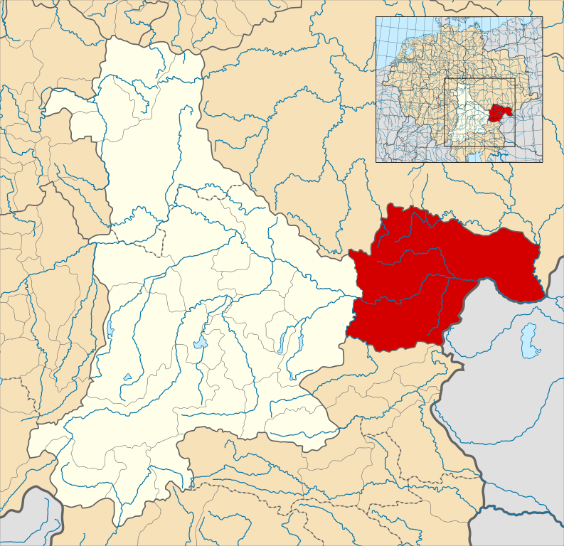
English: A map of the Margraviate of Austria (German: Markgrafschaft Österreich; Old High German: Ostarrîchi) within the Duchy of Bavaria around the year 1000.
The map is derived from a vectorised version of one found in Professor G. Droysens Allgemeiner Historischer Handatlas, which was published in 1886 by R. Andrée Plate, and is now in the public domain. Note that while it uses the same scheme as standard location/locator maps, this map technically does not conform to the standard, as it is not in equirectangular projection. Therefore grid lines for latitude and longitude are also included on the sub-map. |
| Թվական | |
| Աղբյուր |
File: own work Data: File:Droysens-22-23.jpg |
| Հեղինակ | Alphathon /ˈæɫfə.θɒn/ (talk) |
| Այլ մեկնակերպներ |
|
.svg)
.svg)

.svg)
.svg)
.svg)
Արտոնագրում
This file is licensed under the Creative Commons Attribution-Share Alike 4.0 International license.
- Դուք ազատ եք՝
- կիսվել ստեղծագործությամբ – պատճենել, տարածել և փոխանցել այս աշխատանքը։
- վերափոխել – ադապտացնել աշխատանքը
- Պահպանելով հետևյալ պայմանները'
- հղում – Դուք պետք է նշեք հեղինակի (իրավատիրոջ) հղումը:
- համանման տարածում – Եթե դուք ձևափոխում եք, փոխակերպում, կամ այս աշխատանքի հիման վրա ստեղծում եք նոր աշխատանք, ապա ձեր ստեղծածը կարող է տարածվել միայն նույն կամ համարժեք թույլատրագրով։
Նիշքի պատմություն
Մատնահարեք օրվան/ժամին՝ նիշքի այդ պահին տեսքը դիտելու համար։
| Օր/Ժամ | Մանրապատկեր | Օբյեկտի չափը | Մասնակից | Մեկնաբանություն | |
|---|---|---|---|---|---|
| ընթացիկ | 16:32, 18 Մայիսի 2016 | | 1875 × 1815 (5,74 ՄԲ) | Alphathon | == {{int:filedesc}} == {{Inkscape}} {{Information |Description={{en|A map of the en:Margraviate of Austria (German: ''Markgrafschaft Österreich''; Old High German: ''Ostarrîchi'') within the Duchy of Bavaria around the year 1000. The map is... |
Նիշքի օգտագործում
Հետևյալ էջը հղվում է այս նիշքին՝
Նիշքի համընդհանուր օգտագործում
Հետևյալ այլ վիքիները օգտագործում են այս նիշքը՝
- Օգտագործումը arz.wikipedia.org կայքում
- Օգտագործումը ast.wikipedia.org կայքում
- Օգտագործումը cs.wikipedia.org կայքում
- Օգտագործումը en.wikipedia.org կայքում
- Օգտագործումը eo.wikipedia.org կայքում
- Օգտագործումը es.wikipedia.org կայքում
- Օգտագործումը fi.wikipedia.org կայքում
- Օգտագործումը fr.wikipedia.org կայքում
- Օգտագործումը he.wikipedia.org կայքում
- Օգտագործումը hr.wikipedia.org կայքում
- Օգտագործումը id.wikipedia.org կայքում
- Օգտագործումը it.wikipedia.org կայքում
- Օգտագործումը ko.wikipedia.org կայքում
- Օգտագործումը pl.wikipedia.org կայքում
- Օգտագործումը pt.wikipedia.org կայքում
- Օգտագործումը ru.wikipedia.org կայքում
- Օգտագործումը sl.wikipedia.org կայքում
- Օգտագործումը uk.wikipedia.org կայքում
- Օգտագործումը vi.wikipedia.org կայքում
- Օգտագործումը www.wikidata.org կայքում
- Օգտագործումը zh.wikipedia.org կայքում
.svg)