Պատկեր:1784 Bocage Map of The Bosphorus and the City of Byzantium - Istanbul - Constantinople - Geographicus - Bosphorus-white-1793.jpg
Նախադիտման չափ՝ 800 × 544 պիքսել։ Այլ թույլտվությաններ: 320 × 218 պիքսել | 640 × 436 պիքսել | 1024 × 697 պիքսել | 1280 × 871 պիքսել | 2000 × 1361 պիքսել.
Սկզբնական նիշք (2000 × 1361 փիքսել, նիշքի չափը՝ 665 ԿԲ, MIME-տեսակը՝ image/jpeg)
| Bosphorus and the city of Byzantium. | ||||||
|---|---|---|---|---|---|---|
| Նկարիչ | ||||||
| Title |
Bosphorus and the city of Byzantium. |
|||||
| Նկարագրում |
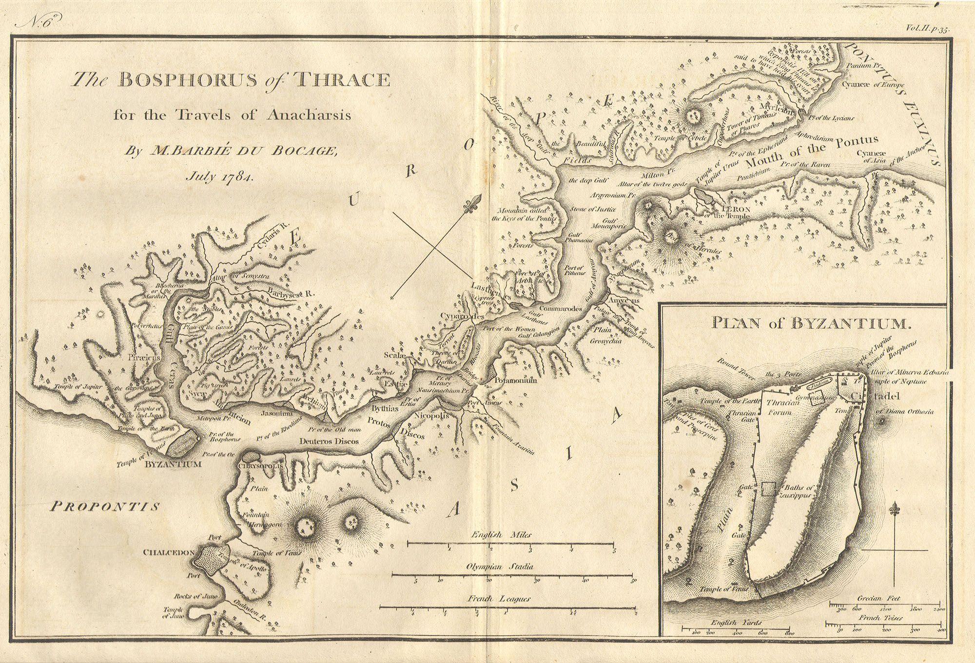
English: This lovely map, depicting the Bosphorus and the city of Byzantium, was prepared by Jean-Denis Barbié du Bocage in 1784 for the “Travels of Anarcharsis”. The map shows the narrow naval passage from the Propontis (Sea of Marmara) to the Pontus Euxinus (Black Sea). There is a beautiful inset plan of the Horn of Byzantium. Today Byzantium is Istanbul, but the horn and many of the ancient structures still exists. This map also shows the area in considerable topographical detail. |
|||||
| Թվական | 1784 | |||||
| Չափեր | բարձրություն: 8,5 in (21,5 cm); լայնություն: 12 in (30,4 cm) | |||||
| ID |
Geographicus link: Bosphorus-white-1793 |
|||||
| Աղբյուր |
|
|||||
| Իրավունքներ (Նիշքի վերաօգտագործումը) |
|
|||||
| Այլ մեկնակերպներ | ||||||

Նիշքի պատմություն
Մատնահարեք օրվան/ժամին՝ նիշքի այդ պահին տեսքը դիտելու համար։
| Օր/Ժամ | Մանրապատկեր | Օբյեկտի չափը | Մասնակից | Մեկնաբանություն | |
|---|---|---|---|---|---|
| ընթացիկ | 20:46, 15 Մարտի 2011 | | 2000 × 1361 (665 ԿԲ) | BotMultichill | {{subst:User:Multichill/Geographicus |link=http://www.geographicus.com/P/AntiqueMap/Bosphorus-white-1793 |product_name=1784 Bocage Map of The Bosphorus and the City of Byzantium / Istanbul / Constantinople |map_title=Bosphorus and the city of Byzantium. | |
Նիշքի օգտագործում
Հետևյալ էջը հղվում է այս նիշքին՝
Նիշքի համընդհանուր օգտագործում
Հետևյալ այլ վիքիները օգտագործում են այս նիշքը՝
- Օգտագործումը ar.wikipedia.org կայքում
- Օգտագործումը arz.wikipedia.org կայքում
- Օգտագործումը ast.wikipedia.org կայքում
- Օգտագործումը az.wikipedia.org կայքում
- Օգտագործումը ca.wikipedia.org կայքում
- Օգտագործումը cs.wikipedia.org կայքում
- Օգտագործումը el.wikipedia.org կայքում
- Օգտագործումը en.wikipedia.org կայքում
- Օգտագործումը eo.wikipedia.org կայքում
- Օգտագործումը eu.wikipedia.org կայքում
- Օգտագործումը gl.wikipedia.org կայքում
- Օգտագործումը he.wikivoyage.org կայքում
- Օգտագործումը hu.wikipedia.org կայքում
- Օգտագործումը it.wikipedia.org կայքում
- Օգտագործումը nap.wikipedia.org կայքում
- Օգտագործումը pt.wikipedia.org կայքում
- Օգտագործումը ro.wikipedia.org կայքում
- Օգտագործումը sk.wikipedia.org կայքում
- Օգտագործումը tr.wikipedia.org կայքում
- Օգտագործումը www.wikidata.org կայքում
- Օգտագործումը zh.wikipedia.org կայքում