Պատկեր:Tornealven.jpg
Ավելի բարձր կետաչափով տարբերակ չկա։
Tornealven.jpg (600 × 572 փիքսել, նիշքի չափը՝ 419 ԿԲ, MIME-տեսակը՝ image/jpeg)
Ամփոփում
| Նկարագրում |
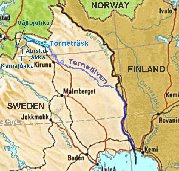
Map of northern Sweden showing location of en:Torne River From CIA mapping (full map is at http://www.lib.utexas.edu/maps/europe/sweden.jpg ) |
| Աղբյուր | CIA |
| Հեղինակ | CIA |
| Այլ մեկնակերպներ | File:Tornealven.png |
Արտոնագրում
| This image is a work of a Central Intelligence Agency employee, taken or made as part of that person's official duties. As a Work of the United States Government, this image or media is in the public domain in the United States.
|

|
Original upload log
The original description page was here. All following user names refer to en.wikipedia.
- 2005-03-12 12:30 ChrisO 300×286×8 (49825 bytes) Map of northern Sweden showing location of [[Torne River]]
Նիշքի պատմություն
Մատնահարեք օրվան/ժամին՝ նիշքի այդ պահին տեսքը դիտելու համար։
| Օր/Ժամ | Մանրապատկեր | Օբյեկտի չափը | Մասնակից | Մեկնաբանություն | |
|---|---|---|---|---|---|
| ընթացիկ | 14:08, 18 Ապրիլի 2014 | | 600 × 572 (419 ԿԲ) | Ulamm | hydrological source added |
| 14:06, 3 Ապրիլի 2007 |  | 300 × 286 (49 ԿԲ) | Frokor | {{Information |Description=Map of northern Sweden showing location of en:Torne River From CIA mapping (full map is at http://www.lib.utexas.edu/maps/europe/sweden.jpg ) |Source=Originally from [http://en.wikipedia.org en.wikipedia]; description page |
Նիշքի օգտագործում
Հետևյալ էջը հղվում է այս նիշքին՝
Նիշքի համընդհանուր օգտագործում
Հետևյալ այլ վիքիները օգտագործում են այս նիշքը՝
- Օգտագործումը af.wikipedia.org կայքում
- Օգտագործումը bg.wikipedia.org կայքում
- Օգտագործումը ca.wikipedia.org կայքում
- Օգտագործումը cs.wikipedia.org կայքում
- Օգտագործումը da.wikipedia.org կայքում
- Օգտագործումը de.wikipedia.org կայքում
- Օգտագործումը es.wikipedia.org կայքում
- Օգտագործումը eu.wikipedia.org կայքում
- Օգտագործումը fi.wikipedia.org կայքում
- Օգտագործումը fr.wikipedia.org կայքում
- Օգտագործումը he.wikipedia.org կայքում
- Օգտագործումը hu.wikipedia.org կայքում
- Օգտագործումը incubator.wikimedia.org կայքում
- Օգտագործումը it.wikipedia.org կայքում
- Օգտագործումը ja.wikipedia.org կայքում
- Օգտագործումը ka.wikipedia.org կայքում
- Օգտագործումը lld.wikipedia.org կայքում
- Օգտագործումը nl.wikipedia.org կայքում
- Օգտագործումը nn.wikipedia.org կայքում
- Օգտագործումը no.wikipedia.org կայքում
- Օգտագործումը pt.wikipedia.org կայքում
- Օգտագործումը ru.wikipedia.org կայքում
- Օգտագործումը sr.wikipedia.org կայքում
- Օգտագործումը sv.wikipedia.org կայքում
- Օգտագործումը www.wikidata.org կայքում
- Օգտագործումը xmf.wikipedia.org կայքում
- Օգտագործումը zh.wikipedia.org կայքում