Պատկեր:LatinMonetaryUnion 1866-1914.svg

Size of this PNG preview of this SVG file: 450 × 456 պիքսել. Այլ թույլտվությաններ: 237 × 240 պիքսել | 474 × 480 պիքսել | 758 × 768 պիքսել | 1011 × 1024 պիքսել | 2021 × 2048 պիքսել.
Սկզբնական նիշք (SVG-նիշք, անվանապես 450 × 456 փիքսել, նիշքի չափը՝ 452 ԿԲ)
Ամփոփում
| Նկարագրում |
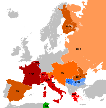
Français : Carte représentant les pays européens participants à l'Union Monétaire Latin entre 1866 et 1914
English: Map showing the European countries participating at the Latin Monetary Union between 1866 and 1914.
Deutsch: Übersicht der europäischen Teilnehmer an der Lateinischen Münzunion zwischen 1866 und 1914.
Die Helligkeit kennzeichnet das ungefähre Beitrittsdatum.
|
||||||||||||||||||||||||
| Թվական | (UTC) | ||||||||||||||||||||||||
| Աղբյուր |
This file was derived from : |
||||||||||||||||||||||||
| Հեղինակ |
|
Արտոնագրում
Այս նիշքը հասանելի է Creative Commons Attribution-Share Alike 3.0 Unported արտոնագրի ներքո:
- Դուք ազատ եք՝
- կիսվել ստեղծագործությամբ – պատճենել, տարածել և փոխանցել այս աշխատանքը։
- վերափոխել – ադապտացնել աշխատանքը
- Պահպանելով հետևյալ պայմանները'
- հղում – Դուք պետք է նշեք հեղինակի (իրավատիրոջ) հղումը:
- համանման տարածում – Եթե դուք ձևափոխում եք, փոխակերպում, կամ այս աշխատանքի հիման վրա ստեղծում եք նոր աշխատանք, ապա ձեր ստեղծածը կարող է տարածվել միայն նույն կամ համարժեք թույլատրագրով։
Original upload log
This image is a derivative work of the following images:
- File:Blank_map_of_Europe_1890.svg licensed with Cc-by-sa-3.0
- 2012-02-21T02:42:58Z Alphathon 450x456 (444331 Bytes) == {{int:filedesc}} == {{Information |Description={{de|Politische Karte [[:de:Europa|Europas]] ca. 1890}} {{en|A blank map of Europe circa 1890 in SVG format.}} |Source={{Derived from|Europa_1890.jpg|Blank_map_of_Europe.svg|d
- File:Blank_map_of_Europe_1914.svg licensed with Cc-by-sa-3.0
- 2012-02-20T23:32:07Z Alphathon 450x456 (462678 Bytes) Fixed Romanian border (Bessarabia should have been Russian)
- 2011-10-31T00:06:48Z Alphathon 450x456 (458338 Bytes) == {{int:filedesc}} == {{Information |Description={{en|Blank map of Europe showing national borders as they stood in 1914.}} |Source=*[[:File:Blank_map_of_Europe.svg|]] |Date=2011-10-31 00:05 (UTC) |Author=*[[:File:Blank_map_
Uploaded with derivativeFX
Նիշքի պատմություն
Մատնահարեք օրվան/ժամին՝ նիշքի այդ պահին տեսքը դիտելու համար։
| Օր/Ժամ | Մանրապատկեր | Օբյեկտի չափը | Մասնակից | Մեկնաբանություն | |
|---|---|---|---|---|---|
| ընթացիկ | 12:29, 8 Հունիսի 2013 | | 450 × 456 (452 ԿԲ) | Sechsachtel | User created page with UploadWizard |
Նիշքի օգտագործում
Հետևյալ էջը հղվում է այս նիշքին՝
Նիշքի համընդհանուր օգտագործում
Հետևյալ այլ վիքիները օգտագործում են այս նիշքը՝
- Օգտագործումը de.wikipedia.org կայքում
- Օգտագործումը en.wikipedia.org կայքում
- Օգտագործումը fr.wikipedia.org կայքում
- Օգտագործումը ht.wikipedia.org կայքում
- Օգտագործումը it.wikipedia.org կայքում
- Օգտագործումը ja.wikipedia.org կայքում
- Օգտագործումը lfn.wikipedia.org կայքում
- Օգտագործումը pl.wikipedia.org կայքում
- Օգտագործումը ro.wikipedia.org կայքում
- Օգտագործումը uk.wikipedia.org կայքում
- Օգտագործումը www.wikidata.org կայքում