Պատկեր:GreaterAmericaMap.jpg

Նախադիտման չափ՝ 800 × 558 պիքսել։ Այլ թույլտվությաններ: 320 × 223 պիքսել | 640 × 446 պիքսել | 1024 × 714 պիքսել | 1280 × 893 պիքսել | 1537 × 1072 պիքսել.
Սկզբնական նիշք (1537 × 1072 փիքսել, նիշքի չափը՝ 325 ԿԲ, MIME-տեսակը՝ image/jpeg)

|
This locator map image could be re-created using vector graphics as an SVG file. This has several advantages; see Commons:Media for cleanup for more information. If an SVG form of this image is available, please upload it and afterwards replace this template with
{{vector version available|new image name}}.
It is recommended to name the SVG file “GreaterAmericaMap.svg”—then the template Vector version available (or Vva) does not need the new image name parameter. |


Ամփոփում
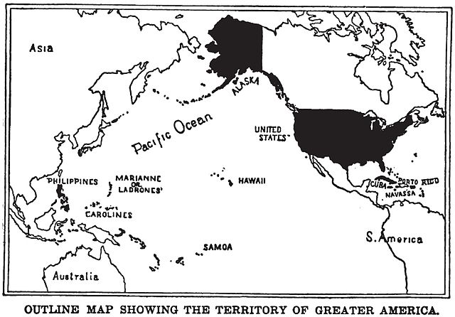
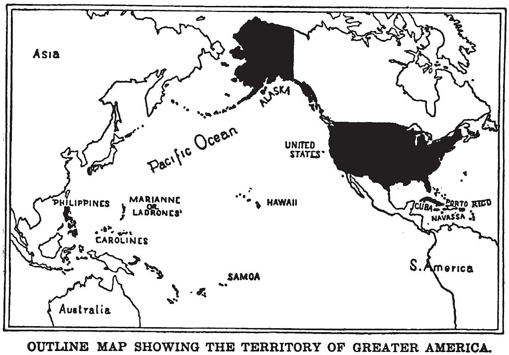
English: Map of "Greater America", 1899.
Shows territories and possessions of the United States after the Spanish American War, including Alaska, Cuba, Hawaii, Marianas, Philippines, Puerto Rico, and Samoa in addition to the continental United States.
Printed in book "War in the Philippines" by Marshall Everet.
Scanned from original 1899 printing by Infrogmation, previously uploaded by him to en:Wikipedia 23:36, 22 October 2003
en:Image:GreaterAmericaMap.jpg
Արտոնագրում
This media file is in the public domain in the United States. This applies to U.S. works where the copyright has expired, often because its first publication occurred prior to January 1, 1929, and if not then due to lack of notice or renewal. See this page for further explanation.
|
 | |
 |
This image might not be in the public domain outside of the United States; this especially applies in the countries and areas that do not apply the rule of the shorter term for US works, such as Canada, Mainland China (not Hong Kong or Macao), Germany, Mexico, and Switzerland. The creator and year of publication are essential information and must be provided. See Wikipedia:Public domain and Wikipedia:Copyrights for more details.
|
Նիշքի պատմություն
Մատնահարեք օրվան/ժամին՝ նիշքի այդ պահին տեսքը դիտելու համար։
| Օր/Ժամ | Մանրապատկեր | Օբյեկտի չափը | Մասնակից | Մեկնաբանություն | |
|---|---|---|---|---|---|
| ընթացիկ | 22:17, 24 Օգոստոսի 2010 | | 1537 × 1072 (325 ԿԲ) | Quazgaa | Higher Res |
| 12:55, 23 Մայիսի 2005 |  | 571 × 391 (70 ԿԲ) | Shizhao | Map of "Greater America", scanned from 1899 book. Shows territories and possessions of the United States after the Spanish American War, including Alaska, Cuba, Hawaii, Marianas, Philippines, Puerto Rico, and Samoa |
Նիշքի օգտագործում
Հետևյալ էջը հղվում է այս նիշքին՝
Նիշքի համընդհանուր օգտագործում
Հետևյալ այլ վիքիները օգտագործում են այս նիշքը՝
- Օգտագործումը ba.wikipedia.org կայքում
- Օգտագործումը be.wikipedia.org կայքում
- Օգտագործումը da.wikipedia.org կայքում
- Օգտագործումը en.wikipedia.org կայքում
- Օգտագործումը en.wikibooks.org կայքում
- Օգտագործումը en.wikiquote.org կայքում
- Օգտագործումը es.wikipedia.org կայքում
- Օգտագործումը fa.wikipedia.org կայքում
- Օգտագործումը fr.wikipedia.org կայքում
- Օգտագործումը hu.wikipedia.org կայքում
- Օգտագործումը id.wikipedia.org կայքում
- Օգտագործումը it.wikipedia.org կայքում
- Օգտագործումը ja.wikipedia.org կայքում
- Օգտագործումը ko.wikipedia.org կայքում
- Օգտագործումը nl.wikipedia.org կայքում
- Օգտագործումը no.wikipedia.org կայքում
- Օգտագործումը pl.wikipedia.org կայքում
- Օգտագործումը pt.wikipedia.org կայքում
- Օգտագործումը ru.wikipedia.org կայքում
- Օգտագործումը tt.wikipedia.org կայքում
- Օգտագործումը uk.wikipedia.org կայքում
- Օգտագործումը vi.wikipedia.org կայքում
- Օգտագործումը zh.wikipedia.org կայքում