Պատկեր:Europe map 450.PNG
Ավելի բարձր կետաչափով տարբերակ չկա։
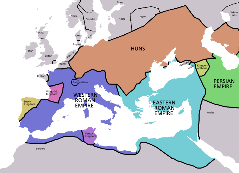
Europe_map_450.PNG (800 × 580 փիքսել, նիշքի չափը՝ 145 ԿԲ, MIME-տեսակը՝ image/png)

|
This historical map image could be re-created using vector graphics as an SVG file. This has several advantages; see Commons:Media for cleanup for more information. If an SVG form of this image is available, please upload it and afterwards replace this template with
{{vector version available|new image name}}.
It is recommended to name the SVG file “Europe map 450.svg”—then the template Vector version available (or Vva) does not need the new image name parameter. |
Ամփոփում
Español: Europa en el 450.
Map of Europe in 450 AD, based on free map of europe Image:BlankMap-Europe.png. Many of the border lines are approximations. Information from Penguin Atlas of Medieval History - and Harper Collins Atlas of World History ed. by Geoffrey Barraclough, second revised edition 1989 pp. 88-89 and pp. 106-107
_en.png)
.png)
.jpg)
Արտոնագրում

|
Այս վավերագրման պատճենահանման, տարածման և/կամ ձևափոխման թույլտվություն կամ լիցենզիայի GNU FDL պայմաններով 1.2 մեկնակերպի կամ ավելի ուշ, հրատարակված Ազատ ծրագրային ապահովության հիմնադրամում, առանց անփոփոխելի հատվածների, առանց բնագիրների, որոնք տեղադրված են առաջին և վերջին շապիկներում: Լիցենզիայի պատճենը գտնվում է GNU Free Documentation License հատվածում: |
| Այս նիշքը հասանելի է Creative Commons Attribution-Share Alike 3.0 Unported արտոնագրի ներքո: | ||
| ||
| Այս արտոնգրության հատկանիշը ավելացված է տվյալ նիշքին որպես GFDL արտոնագրի բարեփոխում: |
Նիշքի պատմություն
Մատնահարեք օրվան/ժամին՝ նիշքի այդ պահին տեսքը դիտելու համար։
| Օր/Ժամ | Մանրապատկեր | Օբյեկտի չափը | Մասնակից | Մեկնաբանություն | |
|---|---|---|---|---|---|
| ընթացիկ | 22:30, 4 Ապրիլի 2009 | | 800 × 580 (145 ԿԲ) | DJ Sturm | Detailed Northern Europa |
| 02:52, 12 հունվարի 2007 |  | 800 × 580 (141 ԿԲ) | Roke~commonswiki | ||
| 13:38, 5 Մայիսի 2006 |  | 2275 × 1649 (111 ԿԲ) | Roke~commonswiki | Map of Europe in 220BC, based on free map of europe Image:BlankMap-Europe.png. Many of the border lines are approximations. {{Europe}} Category: Historical maps of Europe |
Նիշքի օգտագործում
Հետևյալ էջը հղվում է այս նիշքին՝
Նիշքի համընդհանուր օգտագործում
Հետևյալ այլ վիքիները օգտագործում են այս նիշքը՝
- Օգտագործումը af.wikipedia.org կայքում
- Օգտագործումը ar.wikipedia.org կայքում
- Օգտագործումը ast.wikipedia.org կայքում
- Օգտագործումը bs.wikipedia.org կայքում
- Օգտագործումը ckb.wikipedia.org կայքում
- Օգտագործումը cs.wikipedia.org կայքում
- Օգտագործումը da.wikipedia.org կայքում
- Օգտագործումը de.wikipedia.org կայքում
- Օգտագործումը el.wikipedia.org կայքում
- Օգտագործումը en.wikipedia.org կայքում
- Օգտագործումը en.wiktionary.org կայքում
- Օգտագործումը eo.wikipedia.org կայքում
- Օգտագործումը es.wikipedia.org կայքում
- Օգտագործումը es.wikiquote.org կայքում
- Օգտագործումը et.wikipedia.org կայքում
- Օգտագործումը fa.wikipedia.org կայքում
- Օգտագործումը fi.wikipedia.org կայքում
- Օգտագործումը fr.wikipedia.org կայքում
- Օգտագործումը fy.wikipedia.org կայքում
- Օգտագործումը gl.wikipedia.org կայքում
- Օգտագործումը he.wikipedia.org կայքում
- Օգտագործումը hr.wikipedia.org կայքում
- Օգտագործումը hu.wikipedia.org կայքում
- Օգտագործումը id.wikipedia.org կայքում
- Օգտագործումը io.wikipedia.org կայքում
- Օգտագործումը it.wikipedia.org կայքում
- Օգտագործումը ja.wikipedia.org կայքում
- Օգտագործումը ko.wikipedia.org կայքում
- Օգտագործումը ku.wikipedia.org կայքում
- Օգտագործումը lt.wikipedia.org կայքում
- Օգտագործումը mk.wikipedia.org կայքում
- Օգտագործումը nl.wikipedia.org կայքում
Տեսնել այս նիշքի ավելի համընդհանուր օգտագործումը: