Պատկեր:Divided Yemen.svg

Size of this PNG preview of this SVG file: 800 × 483 պիքսել. Այլ թույլտվությաններ: 320 × 193 պիքսել | 640 × 386 պիքսել | 1024 × 618 պիքսել | 1280 × 772 պիքսել | 2560 × 1544 պիքսել | 1210 × 730 պիքսել.
Սկզբնական նիշք (SVG-նիշք, անվանապես 1210 × 730 փիքսել, նիշքի չափը՝ 71 ԿԲ)

|
Այս SVG ֆայլ օգտագործում է զետեղված տեքստ, որը կարելի է հեշտ թարգմանել ձեր լեզվի վրա using [toolforge:svgtranslate/File:Divided_Yemen.svglink this automated tool]: Իմացեք ավելին: You can also download it and translate it manually using a text editor. |
Ամփոփում
| Նկարագրում |
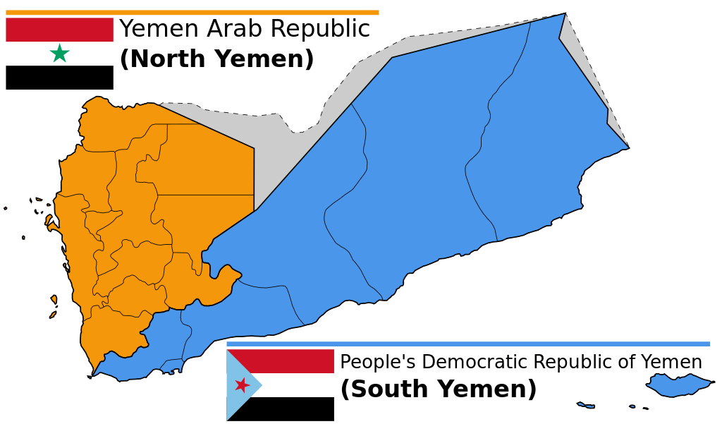
English: Map of North and South Yemen prior to unification.
Español: Yemen previo a la unificación, en 1990.
Français : Le Yémen avant l'unification.
Português: Iêmen do Norte (em laranja) e Iêmen do Sul (em azul) antes de 1990. |
| Թվական | (UTC) |
| Աղբյուր | |
| Հեղինակ |
|
| Այլ մեկնակերպներ |
|


.svg)


Արտոնագրում
Այս նիշքը հասանելի է Creative Commons Attribution-Share Alike 3.0 Unported արտոնագրի ներքո:
- Դուք ազատ եք՝
- կիսվել ստեղծագործությամբ – պատճենել, տարածել և փոխանցել այս աշխատանքը։
- վերափոխել – ադապտացնել աշխատանքը
- Պահպանելով հետևյալ պայմանները'
- հղում – Դուք պետք է նշեք հեղինակի (իրավատիրոջ) հղումը:
- համանման տարածում – Եթե դուք ձևափոխում եք, փոխակերպում, կամ այս աշխատանքի հիման վրա ստեղծում եք նոր աշխատանք, ապա ձեր ստեղծածը կարող է տարածվել միայն նույն կամ համարժեք թույլատրագրով։
Original upload log
This image is a derivative work of the following images:
- File:Map_of_North_and_South_Yemen.png licensed with Cc-by-sa-3.0, GFDL
- 2011-03-21T17:54:35Z Orange Tuesday 1600x1024 (63249 Bytes) 1600 px wide
- 2011-03-21T17:51:50Z Orange Tuesday 1598x1024 (63069 Bytes) {{Information |Description ={{en|1=Map of North and South Yemen prior to unification.}} |Source ={{own}} |Author =[[User:Orange Tuesday|Orange Tuesday]] |Date = |Permission = |other_versions =
- File:Flag_of_North_Yemen.svg licensed with PD-shape
- 2011-08-22T05:56:53Z Alkari 900x600 (731 Bytes) code cleanup; star precision; file size
- 2010-06-27T03:28:25Z Fry1989 900x600 (2295 Bytes) red
- 2006-01-17T05:29:39Z B1mbo 900x600 (665 Bytes) Few corrections
- 2006-01-17T05:15:33Z B1mbo 900x600 (1963 Bytes) == Sumario == {{en|Flag of the [[:en:Yemen Arab Republic|Yemen Arab Republic (North Yemen)]] (1962-1990)}} {{es|Bandera de la [[:es:Yemen del Norte|República Árabe de Yemen (Yemen del Norte)]] (1962-1990)}} [[Category:Flag
- File:Flag_of_South_Yemen.svg licensed with PD-self
- 2011-08-22T06:02:04Z Alkari 1800x1200 (804 Bytes) code cleanup; star precision
- 2010-06-27T03:26:35Z Fry1989 1800x1200 (2702 Bytes) shades
- 2006-01-08T18:55:08Z Dbenbenn 1800x1200 (946 Bytes) by me, PD. Based on https://www.fotw.info/flags/ye-south.html
- 2006-01-04T23:52:54Z Chanheigeorge 195x130 (3741 Bytes) Converted from Image:South_Yemen_Flag.PNG
- File:Governorates_of_Yemen_named.svg licensed with Cc-by-sa-2.5,2.0,1.0, Cc-by-sa-3.0-migrated, GFDL
- 2007-05-23T17:35:54Z Jarke 1208x719 (77247 Bytes) == Sumario == {{Information |Description={{en|Governorates of Yemen, after 2004}} {{es|Governaciones de Yemen, después del 2004}} |Source=SVG version of [[:Image:Yemen governorates numbered english.png]] and [[:Imagen:Yemen
Uploaded with derivativeFX
Նիշքի պատմություն
Մատնահարեք օրվան/ժամին՝ նիշքի այդ պահին տեսքը դիտելու համար։
| Օր/Ժամ | Մանրապատկեր | Օբյեկտի չափը | Մասնակից | Մեկնաբանություն | |
|---|---|---|---|---|---|
| ընթացիկ | 14:58, 20 Դեկտեմբերի 2023 | | 1210 × 730 (71 ԿԲ) | אורי9 | File uploaded using svgtranslate tool (https://svgtranslate.toolforge.org/). Added translation for he. |
| 19:47, 8 Նոյեմբերի 2020 |  | 1210 × 730 (71 ԿԲ) | Panam2014 | Reverted to version as of 18:27, 8 July 2019 (UTC) | |
| 08:46, 9 Օգոստոսի 2020 |  | 1210 × 730 (44 ԿԲ) | AlMahra67 | text | |
| 18:05, 3 Օգոստոսի 2020 |  | 1210 × 730 (39 ԿԲ) | AlMahra67 | Changed dimensions | |
| 17:50, 3 Օգոստոսի 2020 |  | 512 × 309 (39 ԿԲ) | AlMahra67 | If this map is supposed to show South and North Yemen division currently then it should be like this. The current divisions are based on the former divisions between the North and South Yemen. The previous version showed the new administrative boundaries that were created after unity. The new administrative boundary split areas that were part of the south. For example Dhale and Mukayras are shown as part of the North when they are in fact Southern. | |
| 23:07, 11 Օգոստոսի 2019 |  | 1210 × 730 (47 ԿԲ) | SharabSalam | Reverted to version as of 19:35, 20 October 2012 (UTC) none of these sources support this map. This map suppose to show South and North Yemen division currently.. Also Asir, Jazan and Najran should be part of North Yemen if it's a historical map. | |
| 18:27, 8 Հուլիսի 2019 |  | 1210 × 730 (71 ԿԲ) | Flappiefh | This map is supposed to show these two former countries before their union (before 1990). It now shows the right governorates. Source 1 : https://legacy.lib.utexas.edu/maps/atlas_middle_east/yemen_divisions.jpg Source 2 : http://users.ox.ac.uk/~metheses/Ismail%20Thesis.pdf | |
| 11:57, 23 Սեպտեմբերի 2018 |  | 1210 × 730 (68 ԿԲ) | Nicolay Sidorov | ... | |
| 11:52, 23 Սեպտեմբերի 2018 |  | 1210 × 730 (65 ԿԲ) | Nicolay Sidorov | true border | |
| 08:59, 11 Հունիսի 2016 |  | 1210 × 730 (47 ԿԲ) | Flappiefh | Removed Dhale Governorate because it didn't exist at that time (created after 1990 unification). |
Նիշքի օգտագործում
Հետևյալ էջը հղվում է այս նիշքին՝
Նիշքի համընդհանուր օգտագործում
Հետևյալ այլ վիքիները օգտագործում են այս նիշքը՝
- Օգտագործումը af.wikipedia.org կայքում
- Օգտագործումը bn.wikipedia.org կայքում
- Օգտագործումը ca.wikipedia.org կայքում
- Օգտագործումը cs.wikipedia.org կայքում
- Օգտագործումը en.wikipedia.org կայքում
- Օգտագործումը es.wikipedia.org կայքում
- Օգտագործումը eu.wikipedia.org կայքում
- Օգտագործումը fa.wikipedia.org կայքում
- Օգտագործումը fi.wikipedia.org կայքում
- Օգտագործումը fr.wikipedia.org կայքում
- Օգտագործումը gl.wikipedia.org կայքում
- Օգտագործումը he.wikipedia.org կայքում
- פורטל:גאוגרפיה/הידעת?/קטעי הידעת
- פורטל:המזרח התיכון/הידעת?/קטעי הידעת?
- ויקיפדיה:הידעת?/ממרץ 2016
- איחוד תימן
- ויקיפדיה:הידעת?/2017/ינואר
- תבנית:הידעת? 071
- תבנית:הידעת? 30 בינואר 2017
- ויקיפדיה:הידעת?/2021/אוקטובר
- תבנית:הידעת? 20 באוקטובר 2021
- פורטל:גאוגרפיה/הידעת?/34
- פורטל:המזרח התיכון/הידעת?/63
- התנועה הדרומית
- Օգտագործումը hr.wikipedia.org կայքում
- Օգտագործումը hu.wikipedia.org կայքում
- Օգտագործումը id.wikipedia.org կայքում
- Օգտագործումը it.wikipedia.org կայքում
- Օգտագործումը ja.wikipedia.org կայքում
- Օգտագործումը ka.wikipedia.org կայքում
- Օգտագործումը ms.wikipedia.org կայքում
- Օգտագործումը nl.wikipedia.org կայքում
- Օգտագործումը nn.wikipedia.org կայքում
- Օգտագործումը or.wikipedia.org կայքում
- Օգտագործումը sr.wikipedia.org կայքում
- Օգտագործումը te.wikipedia.org կայքում
- Օգտագործումը tg.wikipedia.org կայքում
- Օգտագործումը tr.wikipedia.org կայքում
Տեսնել այս նիշքի ավելի համընդհանուր օգտագործումը: