Պատկեր:Byzantine Macedonia 1045CE.svg

Սկզբնական նիշք (SVG-նիշք, անվանապես 423 × 335 փիքսել, նիշքի չափը՝ 457 ԿԲ)
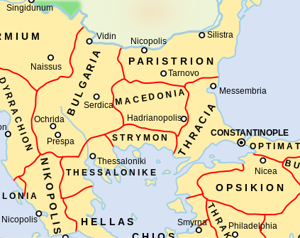
Diese Karte stimmt nicht mit dem Historischen Atlas überein eine Fehlinformation.
Ամփոփում
| Նկարագրում |
Català: Un mapa que mostra els temes bizantins (unitats administratives) de l'Imperi Bizantí l'any 1045 dC, centrat en els Balcans centrals al voltant de la regió de Macedònia. El tema macedoni es troba en el que avui forma part de l'actual Bulgària, mentre que el tema búlgar inclou el que avui és la República de Macedònia del Nord. Tingueu en compte que els límits temàtics d'aquest mapa, especialment els d'Estrímon i Macedònia, són molt inexactes. Macedònia es trobava realment més al sud, fins a la costa de l'Egeu de Tràcia occidental
English: A map showing the Byzantine themata (administrative units) of the Byzantine Empire in 1045 CE, focusing on central Balkans around the region of Macedonia. The Macedonian thema is in what today is part of present-day Bulgaria, while the Bulgarian thema includes what today is the Republic of North Macedonia. Note that the thematic boundaries in this map, especially those of Strymon and Macedonia, are very inaccurate. Macedonia was actually located further south, up to the Aegean coast of western Thrace |
| Թվական | |
| Աղբյուր | This is a derivative work of a more complete map created by ArdadN of the English Wikipedia. |
| Հեղինակ | NerdyNSK |
| Իրավունքներ (Նիշքի վերաօգտագործումը) |
GFDL-1.2+, CC-BY-SA-3.0/2.5/2.0/1.0 |
| Այլ մեկնակերպներ |
This is a derivative work of a more complete map created by ArdadN of the English Wikipedia. File:Byzantine Macedonia 1045CE.svg has 2 translations.
Other related versions: []
|


|
Այս SVG ֆայլ օգտագործում է զետեղված տեքստ, որը կարելի է հեշտ թարգմանել ձեր լեզվի վրա using [toolforge:svgtranslate/File:Byzantine_Macedonia_1045CE.svglink this automated tool]: Իմացեք ավելին: You can also download it and translate it manually using a text editor. |
This file is translated using SVG For most Wikipedia projects, you can embed the file normally (without a To translate the text into your language, you can use the SVG Translate tool. Alternatively, you can download the file to your computer, add your translations using whatever software you're familiar with, and re-upload it with the same name. You will find help in Graphics Lab if you're not sure how to do this. |
Արտոնագրում

|
Այս վավերագրման պատճենահանման, տարածման և/կամ ձևափոխման թույլտվություն կամ լիցենզիայի GNU FDL պայմաններով 1.2 մեկնակերպի կամ ավելի ուշ, հրատարակված Ազատ ծրագրային ապահովության հիմնադրամում, առանց անփոփոխելի հատվածների, առանց բնագիրների, որոնք տեղադրված են առաջին և վերջին շապիկներում: Լիցենզիայի պատճենը գտնվում է GNU Free Documentation License հատվածում: |
- Դուք ազատ եք՝
- կիսվել ստեղծագործությամբ – պատճենել, տարածել և փոխանցել այս աշխատանքը։
- վերափոխել – ադապտացնել աշխատանքը
- Պահպանելով հետևյալ պայմանները'
- հղում – Դուք պետք է նշեք հեղինակի (իրավատիրոջ) հղումը:
- համանման տարածում – Եթե դուք ձևափոխում եք, փոխակերպում, կամ այս աշխատանքի հիման վրա ստեղծում եք նոր աշխատանք, ապա ձեր ստեղծածը կարող է տարածվել միայն նույն կամ համարժեք թույլատրագրով։
Նիշքի պատմություն
Մատնահարեք օրվան/ժամին՝ նիշքի այդ պահին տեսքը դիտելու համար։
| Օր/Ժամ | Մանրապատկեր | Օբյեկտի չափը | Մասնակից | Մեկնաբանություն | |
|---|---|---|---|---|---|
| ընթացիկ | 16:05, 11 փետրվարի 2024 | | 423 × 335 (457 ԿԲ) | Manlleus | File uploaded using svgtranslate tool (https://svgtranslate.toolforge.org/). Added translation for ca. |
| 07:58, 10 փետրվարի 2024 |  | 423 × 335 (457 ԿԲ) | Leptictidium | File uploaded using svgtranslate tool (https://svgtranslate.toolforge.org/). Added translation for ca. | |
| 07:50, 10 փետրվարի 2024 |  | 423 × 335 (457 ԿԲ) | Leptictidium | File uploaded using svgtranslate tool (https://svgtranslate.toolforge.org/). Added translation for ca. | |
| 19:52, 9 փետրվարի 2024 |  | 423 × 335 (447 ԿԲ) | Manlleus | added catalan language | |
| 21:30, 4 Մայիսի 2017 |  | 423 × 335 (407 ԿԲ) | Kandi | Reverted to version as of 05:00, 4 April 2008 (UTC) | |
| 21:15, 4 Մայիսի 2017 |  | 4252 × 6013 (317 ԿԲ) | Kandi | new, more detailed version | |
| 05:00, 4 Ապրիլի 2008 |  | 423 × 335 (407 ԿԲ) | NerdyNSK | {{Information |Description=A map showing the Byzantine themata (administrative units) of the Byzantine Empire in 1045 CE, focusing on central Balkans around the region of Macedonia. The Macedonian thema is in what today is part of present-day Bulgaria, w |
Նիշքի օգտագործում
Հետևյալ էջը հղվում է այս նիշքին՝
Նիշքի համընդհանուր օգտագործում
Հետևյալ այլ վիքիները օգտագործում են այս նիշքը՝
- Օգտագործումը af.wikipedia.org կայքում
- Օգտագործումը als.wikipedia.org կայքում
- Օգտագործումը ar.wikipedia.org կայքում
- Օգտագործումը azb.wikipedia.org կայքում
- Օգտագործումը ba.wikipedia.org կայքում
- Օգտագործումը be.wikipedia.org կայքում
- Օգտագործումը bg.wikipedia.org կայքում
- Օգտագործումը ca.wikipedia.org կայքում
- Օգտագործումը cs.wikipedia.org կայքում
- Օգտագործումը de.wikipedia.org կայքում
- Օգտագործումը el.wikipedia.org կայքում
- Օգտագործումը en.wikipedia.org կայքում
- Օգտագործումը fr.wikipedia.org կայքում
Տեսնել այս նիշքի ավելի համընդհանուր օգտագործումը: