Պատկեր:Bagratuni Armenia 1000-fr.svg

Size of this PNG preview of this SVG file: 800 × 470 պիքսել. Այլ թույլտվությաններ: 320 × 188 պիքսել | 640 × 376 պիքսել | 1024 × 601 պիքսել | 1280 × 751 պիքսել | 2560 × 1503 պիքսել | 2717 × 1595 պիքսել.
Սկզբնական նիշք (SVG-նիշք, անվանապես 2717 × 1595 փիքսել, նիշքի չափը՝ 815 ԿԲ)
Ամփոփում
| Նկարագրում |
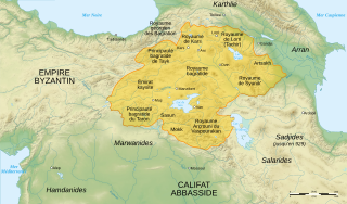
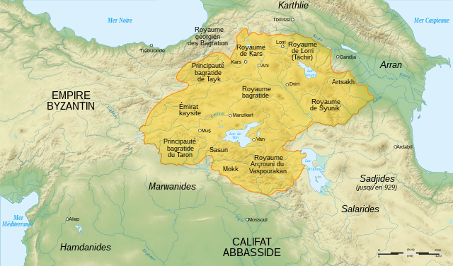
English: Map of Bagratuni Armenia, around the year 1000 AD., with French labels. (original map by G. A. Bournoutian from «A Concise History of the Armenian People», map 15, page 147) Français : Carte de l'Arménie bagratide vers l'an mille, . |
||
| Թվական | |||
| Աղբյուր |
English: Data:
Softwares used :
Geographical data :
Français : Բեռնողի սեփական աշխատանք. Sources :
Logiciels utilisés :
Autres données :
|
||
| Հեղինակ | Sémhur | ||
| Այլ մեկնակերպներ |
[]
|
||
| Հղում (required by the license) | © Sémhur / Wikimedia Commons / | ||
| SVG | W3C-validity not checked. Սա վեկտոր գրաֆիկական պատկեր է ստեղծված է եղել Inkscape օգնությամբ: .
|
||
| Atelier graphique |


| Տեսախցիկի տեղագրություն | | Այս և ուրիշ պատկերներ իրենց տեղագրությամբ OpenStreetMap |
|---|
Արտոնագրում
Ես, այս աշխատանքի հեղինակային իրավունքների տերը, ներկա հրատարակում եմ սրա հետևյալ լիցենզիաների պայմաններով
| Copyleft: This work of art is free; you can redistribute it and/or modify it according to terms of the Free Art License. You will find a specimen of this license on the Copyleft Attitude site as well as on other sites. |
This file is licensed under the Creative Commons Attribution-Share Alike Attribution-Share Alike 4.0 International, 3.0 Unported, 2.5 Generic, 2.0 Generic and 1.0 Generic license.
- Դուք ազատ եք՝
- կիսվել ստեղծագործությամբ – պատճենել, տարածել և փոխանցել այս աշխատանքը։
- վերափոխել – ադապտացնել աշխատանքը
- Պահպանելով հետևյալ պայմանները'
- հղում – Դուք պետք է նշեք հեղինակի (իրավատիրոջ) հղումը:
- համանման տարածում – Եթե դուք ձևափոխում եք, փոխակերպում, կամ այս աշխատանքի հիման վրա ստեղծում եք նոր աշխատանք, ապա ձեր ստեղծածը կարող է տարածվել միայն նույն կամ համարժեք թույլատրագրով։
Կարող եք ընտրել այս թույլատրագրերից ցանկացածը։
Նիշքի պատմություն
Մատնահարեք օրվան/ժամին՝ նիշքի այդ պահին տեսքը դիտելու համար։
| Օր/Ժամ | Մանրապատկեր | Օբյեկտի չափը | Մասնակից | Մեկնաբանություն | |
|---|---|---|---|---|---|
| ընթացիկ | 16:22, 20 Ապրիլի 2021 | | 2717 × 1595 (815 ԿԲ) | Εὐθυμένης | File uploaded using svgtranslate tool (https://svgtranslate.toolforge.org/). Added translation for el. |
| 09:41, 19 Մարտի 2016 |  | 2717 × 1595 (775 ԿԲ) | Taivo | repeatedly uploaded unsourced version | |
| 23:00, 17 Մարտի 2016 |  | 2717 × 1595 (717 ԿԲ) | Georgiano | 1) https://fr.wikipedia.org/wiki/Royaume_des_Kartvels 2) check out land titles of Bagratuni dynasty 3) during VIII-X century Tao (historical region) was part of Kingdom of the Kartvels. before removing my update, add... | |
| 18:57, 26 Դեկտեմբերի 2007 |  | 2717 × 1595 (775 ԿԲ) | Sémhur | {{Information |Description= {{en| French map of Bagratuni Armenia, around the year 1000 AD.}} {{fr| Carte en français de l'Arménie bagratide, vers l'an mille.}} |Source=Travail personnel. {{clr}} Sources : * Fond de carte : [http://www2.jpl.nasa.gov/srt |
Նիշքի օգտագործում
Այս նիշքին օգտագործող էջեր չկան։
Նիշքի համընդհանուր օգտագործում
Հետևյալ այլ վիքիները օգտագործում են այս նիշքը՝
- Օգտագործումը ce.wikipedia.org կայքում
- Օգտագործումը el.wikipedia.org կայքում
- Օգտագործումը fr.wikipedia.org կայքում
- Arménie
- Années 990
- Kars
- Bagratides
- Grégoire de Narek
- Histoire de l'Arménie médiévale
- Horomos
- Achot Ier d'Arménie
- Taron (Arménie)
- Vaspourakan
- Utilisateur:Hayastan07/Architecture arménienne
- Wikipédia:Atelier graphique/Cartes/Archives/janvier 2008
- Chronologie de l'Arménie
- Royaume de Lorri
- Miniature arménienne
- Wikipédia:Atelier graphique/Cartes/Archives/mars 2009
- Histoire de l'Arménie
- Conquête musulmane de l'Arménie
- Օգտագործումը it.wikipedia.org կայքում
- Օգտագործումը pcd.wikipedia.org կայքում
- Օգտագործումը ru.wikipedia.org կայքում
- Օգտագործումը uk.wikipedia.org կայքում
- Օգտագործումը zh.wikipedia.org կայքում